SULINA FREE ZONE ADMINISTRATION
| home | SULINA FREE ZONE | LEGAL BASIS | SULINA TOWN | ACTIVITATIES AND ADVANTAGES | EQUIPMENT – SUBSTRUCTURE | AUCTIONS | MANAGEMENT - CONTACT
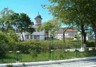
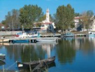
SULINA TOWN

|
SULINA TOWN
Lat. 450 9’ 37’’ N, Long. 290 40’ 37’’
Weather:
Temperate continental, prevailing winds N to NE. Danger of ice in
January and February but icebreaker assistance keeps navigation all
year round.
The river mouth allows the passage of vessels of 7.32 m max. depth.
The Danube crosses over 10 European countries and our
country along 40% from its all-navigable length (of 2.588 km).
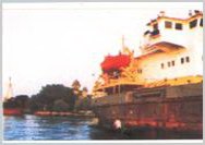
SULINA HARBOUR
Sulina port area has and anchorage/mooring
ships’ place, a shipyard, a ships’ dismantling service and
a Free Zone developed with fitted and unfitted perimeters which offers
the alternative to any investor as well as the goods transit port.
SULINA PORT is located on the right bank of the
Sulina Channel, inside the town’s area and has the following
port-buildings: ferro-concrete vertical quay(length 3.340 l.m.); three
ferro-concrete piers, each having a mooring place of 80 l.m., drought
7,50 m, two ferro-concrete piers with a mooring place of 100 l.m. and
200 l.m., drought 3,50 l.m., two ferro-concrete piers of 30 l.m. each,
2.50 m drought, a 2.600 l.m. stoned packing quay to protect the bank
prolonging the vertical quay up to the water tour.
SULINA SHIPYARD
Is equipped with ferro-concrete vertical quay (length
2160 m) and upstream with stone-packing quay(3600 m). On the left bank
of the Sulina Channel is an industrial unity specialized and equipped
with workshops, equipments, tools and ship’s repairing or
building devices.
The Danube bank of the shipyard has a ship launching
–raising way (until 2.000 t) and pier type quays for assembling
–disassembling of ships(until 15000 dwt) .
|